

Introduction: Why Does Your Location on Earth Change Everything?
Imagine standing on a beach in Miami in July, sweating through a 95°F afternoon. Now picture a researcher at the same time of year, bundled in a thermal suit near the Arctic Circle, watching the thermometer hover just above freezing.
Same planet. Same season. Completely different worlds.
The reason? Latitude.
Of all the factors that shape a place’s climate — ocean currents, altitude, distance from the sea — latitude is arguably the most powerful. It determines how much solar energy a location receives, which in turn drives temperature, rainfall, wind patterns, and seasons.
Whether you’re a student trying to understand geography, a traveler curious about why certain places feel the way they do, or just someone who’s always wondered why the tropics are hot and the poles are frozen — this guide breaks it all down, clearly and completely.
What Is Latitude, and How Is It Measured?
Before diving into climate, it helps to understand exactly what latitude is.
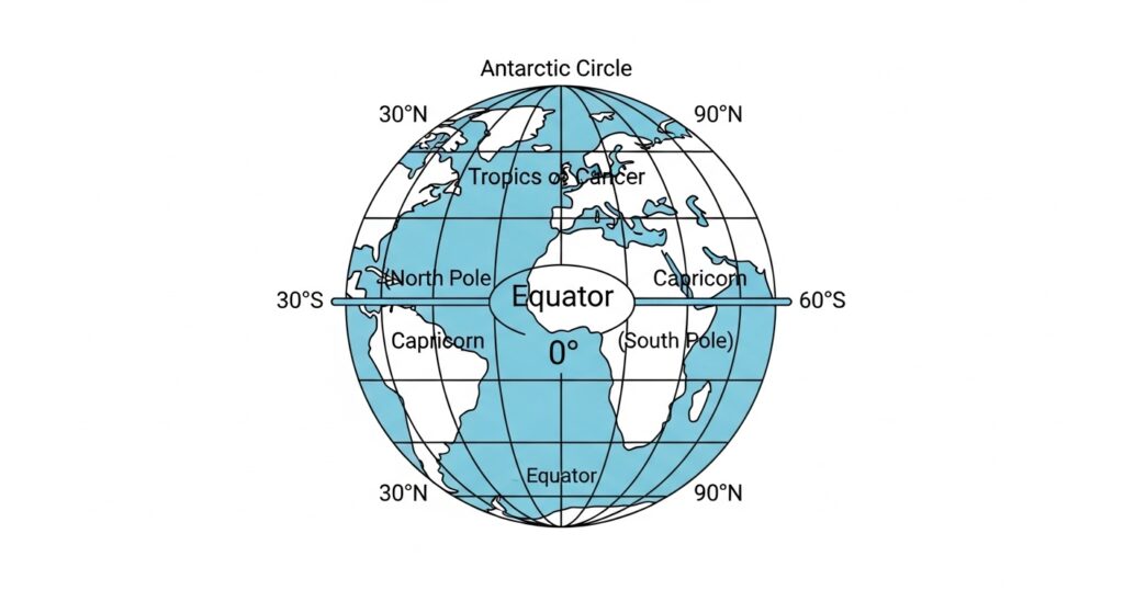
Latitude refers to the angular distance of a location north or south of the Earth’s equator. It’s measured in degrees, ranging from 0° at the equator to 90° at each pole.
Think of latitude lines — also called parallels — as horizontal rings wrapped around the Earth. Each one runs east to west and marks a specific distance from the equator.
Here are the key reference lines:
| Latitude | Name | Notable Feature |
|---|---|---|
| 0° | Equator | Maximum solar energy; tropical climate |
| 23.5° N | Tropic of Cancer | Northernmost point of direct Sun overhead |
| 23.5° S | Tropic of Capricorn | Southernmost point of direct Sun overhead |
| 66.5° N | Arctic Circle | Beginning of polar extremes |
| 66.5° S | Antarctic Circle | Beginning of polar extremes (south) |
| 90° N/S | North/South Pole | Minimum solar energy; coldest climates |
Longitude, by comparison, measures east-west position and has far less effect on climate — more on that later.
How Does Latitude Affect Climate? The Core Mechanism
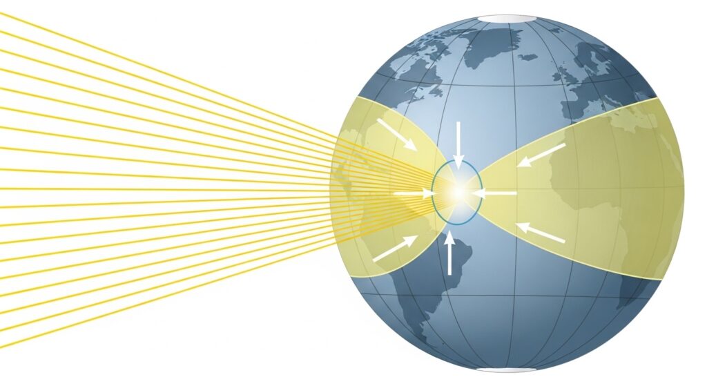
The relationship between latitude and climate comes down to one thing: the angle at which sunlight hits the Earth’s surface.
The Sun Angle Explanation
The Earth is a sphere. Because of its curved shape, solar radiation doesn’t strike every point on the surface at the same angle.
At low latitudes (near the equator), sunlight arrives nearly straight down — at a high, steep angle. This concentrates energy into a small area, producing intense heat.
At high latitudes (near the poles), the same sunlight hits at a shallow, oblique angle. The energy spreads across a much wider area, making it far less intense. Imagine shining a flashlight straight down onto a table versus tilting it sideways — the tilted beam covers more surface but gives less light per square inch.
This difference in solar angle is the primary engine behind why latitude affects temperature so dramatically.
Daylight Hours Also Play a Role
Beyond the angle of sunlight, latitude also controls how many hours of daylight a location receives.
At the equator, days and nights are nearly equal year-round — about 12 hours each. But move toward the poles, and the extremes become dramatic. In summer at high latitudes, the Sun barely sets. In winter, it barely rises.
This is why places like Fairbanks, Alaska experience over 21 hours of daylight in June and fewer than 4 in December — a contrast that has enormous consequences for temperature, ecology, and human life.
The Three Major Climate Zones Defined by Latitude
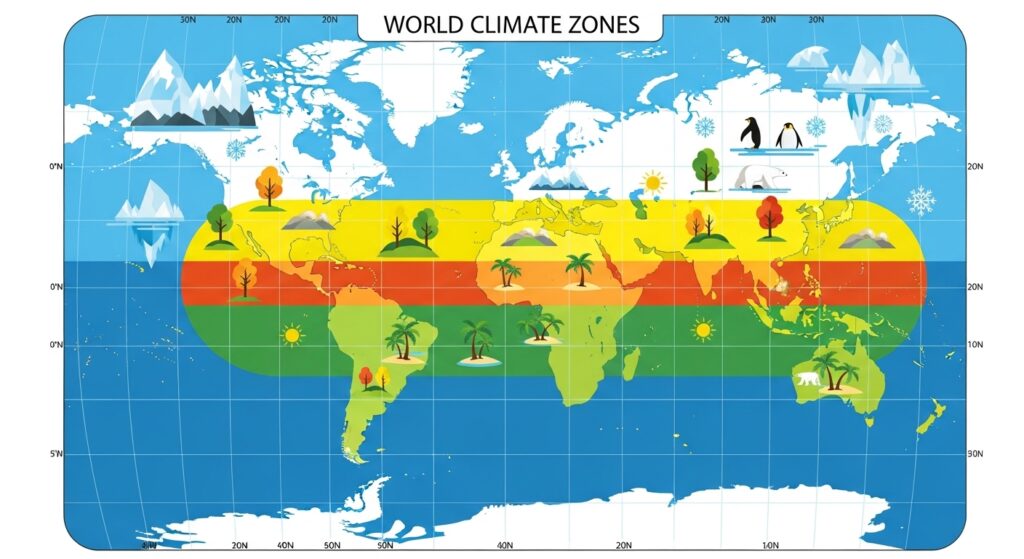
Geographers and climatologists generally divide Earth into three broad climate zones based on latitude:
1. Tropical Zone (0°–23.5°)
The region between the Tropics of Cancer and Capricorn receives the most direct sunlight year-round. Average temperatures are consistently high — often above 77°F (25°C) — and the seasons are defined not by temperature change but by wet and dry periods.
This zone includes the Amazon Rainforest, central Africa, Southeast Asia, and northern Australia. According to NASA, the tropics absorb far more solar energy than they emit back into space, making them the planet’s primary heat engine.
Rainfall is generally abundant near the equator, driven by rising warm, moist air — a process central to the Intertropical Convergence Zone (ITCZ).
2. Temperate Zone (23.5°–66.5°)
The temperate zones sit on either side of the tropics and are home to the most climatic variety. These regions experience four distinct seasons because the angle of sunlight changes significantly between summer and winter as Earth tilts on its axis.
Countries like the United States, the UK, most of Europe, China, and Japan fall within the temperate zone. Temperatures can range from freezing winters to hot summers, depending on proximity to oceans, altitude, and other modifying factors.
The temperate zone is also where most of the world’s population lives — partly because the climate is stable and agriculturally productive.
3. Polar Zone (66.5°–90°)
At high latitudes, sunlight arrives at such a shallow angle that even during the long summer days, it delivers relatively little energy per square meter. The result is extreme cold, sparse precipitation (mostly snow), and ecosystems built for survival in harsh conditions.
The Arctic and Antarctic regions experience months of total darkness in winter and perpetual daylight in summer — a phenomenon called polar night and midnight sun, documented by meteorological services.
How Latitude Affects Temperature: By the Numbers
The relationship between latitude and temperature is one of the clearest patterns in climate science.
As a general rule, temperatures drop by roughly 0.5°C to 1°C for every degree of latitude you move away from the equator — though this varies considerably based on local geography.
Consider these average annual temperatures:
| City | Approximate Latitude | Average Annual Temp |
|---|---|---|
| Singapore | 1° N | 81°F (27°C) |
| Miami, USA | 25° N | 77°F (25°C) |
| New York City, USA | 41° N | 55°F (13°C) |
| London, UK | 51° N | 52°F (11°C) |
| Oslo, Norway | 60° N | 43°F (6°C) |
| Barrow, Alaska | 71° N | 12°F (-11°C) |
The trend is unmistakable. The further you move from the equator, the colder it gets — on average.
NOAA’s climate data consistently shows this latitudinal temperature gradient, though it acknowledges that ocean currents (like the Gulf Stream), land distribution, and urban heat islands can significantly modify local conditions.
How Latitude Affects Weather Patterns and Precipitation
Temperature isn’t the only thing shaped by latitude. Weather patterns — including wind systems, precipitation, and storm tracks — are all deeply connected to where a location sits on the globe.
Global atmospheric pressure and wind belts by latitude
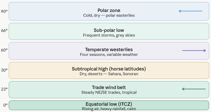
Global Wind Belts and Pressure Systems
Earth’s atmosphere organizes itself into distinct bands of wind and pressure — all determined by latitude. Here’s how it works:
Near the equator (0°–10°): Intense solar heating causes air to rise, creating a zone of low pressure and calm winds. This is the Intertropical Convergence Zone (ITCZ) — famous among sailors as the “doldrums.” Rising air cools, releases moisture, and produces the heavy rainfall that feeds tropical rainforests.
Subtropical high-pressure belts (around 30°): Air that rose at the equator descends here, creating high pressure, dry conditions, and calm winds called the “horse latitudes.” Not coincidentally, most of Earth’s major deserts — the Sahara, Arabian, Sonoran, Australian — sit near 30° latitude.
Temperate westerlies (30°–60°): In the mid-latitudes, winds blow predominantly from west to east, driving the variable and often stormy weather that characterizes places like the UK and the central United States.
Polar easterlies (60°–90°): Cold, dense air sinks at the poles and flows outward toward lower latitudes, creating frigid easterly winds.
These global circulation patterns are described in detail by NOAA’s educational resources on atmospheric circulation.
Does Longitude Affect Climate? Latitude vs. Longitude
This is a common question — and the answer is nuanced.
Longitude (east-west position) has minimal direct effect on climate. There’s no systematic relationship between how far east or west you are and how hot, cold, wet, or dry your climate is. Cities at the same longitude can experience wildly different climates.
However, longitude does matter indirectly through its relationship to:
- Continentality — how far a location is from the ocean. Continental interiors (far from coasts, regardless of longitude) tend to have more extreme temperature swings.
- Prevailing winds — whether a location is on the windward or leeward side of mountain ranges or coastlines.
- Ocean currents — warm and cold currents that run along certain longitudes can dramatically modify local climates.
The bottom line: latitude is the primary driver of climate; longitude modifies it through geography.
How Do Latitude and Altitude Affect Climate Together?
Altitude (elevation above sea level) works similarly to latitude — but vertically rather than horizontally.
As you go higher, the atmosphere thins and retains less heat, so temperatures drop. The standard rate is approximately 3.5°F per 1,000 feet of elevation gain (or about 6.5°C per 1,000 meters), a value known as the environmental lapse rate.
This is why:
- Mount Kilimanjaro sits near the equator in Tanzania yet has permanent glaciers at its summit
- Mexico City (at 7,350 feet elevation) has a mild, spring-like climate despite being at tropical latitude
- The Andes mountains create dramatic climate contrasts between their eastern and western slopes
Altitude essentially “mimics” higher latitude. A mountain peak at 15°N can feel climatically similar to a low-elevation location at 55°N — both cold, both with limited vegetation.
The combination of latitude and altitude together helps explain why two locations on the same parallel can feel completely different — one on the coast at sea level, the other in the mountains.
Expert Tip: Climate scientists use the concept of lapse rate to model how temperature changes with altitude, which is critical for understanding mountain ecosystems, glacier dynamics, and agricultural zones. The World Meteorological Organization provides global standards for these measurements.
Real-World Examples: How Latitude Shapes Climates We Know
London vs. Moscow — Same Latitude, Different Climates
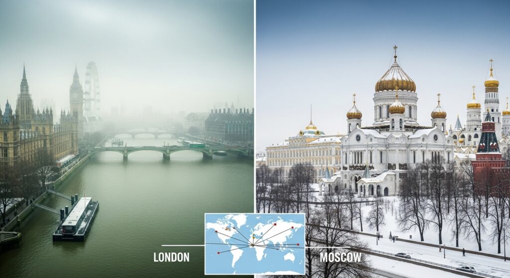
London (51°N) and Moscow (55°N) are at similar latitudes, yet their climates differ significantly. London has mild, wet winters thanks to the warming influence of the Gulf Stream ocean current. Moscow experiences brutal winters that regularly dip below -4°F (-20°C).
This shows that while latitude sets the baseline, ocean currents and continental position adjust the final result.
Why Is Hawaii So Pleasant Year-Round?
Hawaii sits between 19°N and 22°N — well within the tropics. But unlike many tropical regions, it benefits from cooling trade winds and the moderating influence of the Pacific Ocean. The result is a near-perfect climate that rarely gets too hot or too cold — a direct product of its latitude combined with oceanic influence.
The Sahara Desert at 25°N
Many people assume deserts are hot because they’re near the equator. But the Sahara’s extreme aridity actually results from the subtropical high-pressure belt at 25–30°N — a latitude-driven phenomenon that causes descending, dry air masses. As the U.S. Geological Survey explains, desert formation is strongly linked to these pressure systems.
Latitude and Seasons: Why Does It Affect That Too?
Seasons exist because of Earth’s axial tilt of approximately 23.5° — not because of distance from the Sun. As Earth orbits the Sun, different latitudes receive different amounts of direct sunlight at different times of year.
- At low latitudes (tropics), the Sun is always high in the sky. Seasons barely affect temperature — the distinction is wet season vs. dry season.
- At mid-latitudes (temperate zones), the difference in Sun angle between summer and winter is dramatic, creating strong seasonal temperature swings.
- At high latitudes (polar regions), the seasonal extremes are the most severe — long polar nights in winter and continuous daylight in summer.
This is why seasonal temperature variation increases with latitude. Singapore’s temperature barely changes between January and July. New York’s swings by 50°F.
NASA’s Earth Observatory provides excellent resources on how Earth’s orbital geometry drives these seasonal patterns.
Expert Tips: Understanding Latitude’s Climate Effects
Here are a few insights that go beyond the basics:
1. The latitude-climate relationship isn’t perfectly uniform. Ocean currents like the Gulf Stream, the Humboldt Current, and the Kuroshio Current warm or cool coastlines beyond what latitude alone would predict. The National Weather Service regularly uses ocean current data alongside latitude in its climate models.
2. Urban heat islands modify latitude’s effects locally. Dense cities can be 1–3°C warmer than surrounding rural areas at the same latitude, due to pavement, buildings, and human activity — as documented by EPA research on urban heat islands.
3. Climate change is shifting the “expected” latitude patterns. As global temperatures rise, the boundaries between climate zones are gradually shifting poleward. The Arctic is warming roughly four times faster than the global average, according to NOAA — a phenomenon that disrupts the classic latitude-climate relationship.
4. Mountain ranges at mid-latitudes create microclimates. The Rocky Mountains, Alps, and Himalayas all block prevailing winds, creating dry rain shadows on their leeward sides — regardless of the latitude involved.
How Latitude Affects Local Weather
While climate refers to long-term patterns, latitude also shapes day-to-day weather in predictable ways.
At low latitudes, convective thunderstorms are common in the afternoon — hot air rises rapidly, cools, and produces heavy but brief downpours. The weather is intense but often predictable.
At mid-latitudes, the jet stream — a fast-moving ribbon of air at high altitude — plays a huge role in daily weather. Its position (which is latitude-dependent) determines whether cold Arctic air dips southward or warm tropical air pushes north. NOAA’s jet stream page explains how it works.
At high latitudes, weather is dominated by the polar vortex, a large area of low pressure and cold air that sits over the poles. When it weakens, cold air spills southward — causing the extreme winter events that periodically affect the northern United States and Canada.
FAQs: How Does Latitude Affect Climate?
Q1: How does latitude affect climate in simple terms?
Latitude determines how directly the Sun’s energy hits a location. Near the equator, sunlight strikes the ground at a steep angle, concentrating heat and creating hot, humid climates. Toward the poles, sunlight hits at a shallow angle, spreading the energy across a wider area and producing cold climates.
Q2: Why does latitude affect temperature?
It comes down to the angle of solar radiation. At high latitudes, sunlight travels through more atmosphere and spreads over a larger surface area, delivering less energy per square meter. At low latitudes, it hits more directly, concentrating energy and generating higher temperatures.
Q3: Does longitude affect climate?
Longitude has little direct effect on climate, unlike latitude. However, it indirectly influences climate through factors like distance from the ocean (continentality) and exposure to prevailing ocean currents, both of which can significantly modify temperatures.
Q4: How do latitude and altitude affect climate differently?
Latitude affects climate horizontally — the further from the equator, the cooler the climate. Altitude affects it vertically — the higher the elevation, the cooler the conditions. Both reduce the amount of solar energy (or retained heat) a location experiences, though through different mechanisms. A high mountain at low latitude can have a similar climate to a sea-level location at high latitude.
Q5: How does the latitude of a place influence the climate of a specific location?
Every degree of latitude away from the equator generally means a cooler average temperature, shorter growing seasons, and changes in wind patterns and precipitation. But this baseline is modified by local factors: nearby oceans, mountain ranges, prevailing winds, and altitude can all make a specific place warmer, cooler, wetter, or drier than its latitude alone would suggest.
Conclusion: Latitude Is the Starting Point for Every Climate
If you want to understand why any place on Earth has the climate it does, latitude is always the first question to ask.
It’s the variable that sets the stage — determining how much solar energy a location receives, what wind systems blow through it, whether it bakes in tropical heat or shivers in polar cold. Everything else — altitude, ocean currents, mountains, urban development — refines the answer that latitude provides first.
The next time you look at a world map and wonder why the Amazon is lush while the Sahara is barren, why Scandinavia is cold while Florida is warm, or why a mountain peak in the tropics can carry snow — remember the angle of sunlight, the curve of the Earth, and the invisible lines of latitude running silently across the globe.
Understanding latitude isn’t just geography homework. It’s the key to reading the entire planet’s climate system.
Want to explore more about climate science? Check out resources from NASA’s Climate Portal, NOAA Education, and the Met Office for deeper reading on how Earth’s climate works.
